
Rare Earths
Itaquara - BA
The area of mining process no. 871.535/2023 occupies 1999.90ha and is located in the municipalities of Itaquara and Santa Inês, Bahia, Brazil.

HIGHLIGHTS

Tune in to our exclusive podcast showcasing the Rare Earths deposit in Itaquara, Bahia.
LOCATION AND ACCESS ROUTES
The ANM Process 870.353/2023 is located predominantly within the municipality of Itaquara, with its northern section extending into the neighboring municipality of Santa Inês, in the state of Bahia. The main access to the region is via Highway BR-116, one of the country's major routes, connecting Salvador to Bahia's interior and other states.
From BR-116, access is provided by state roads BA-250 and BA-420, which connect the municipalities of Jaguaquara, Santa Inês, and Itaquara, leading to rural roads that reach directly into the area of interest. The unpaved roads leading into the site are, for the most part, in good condition, allowing conventional utility vehicles to operate throughout most of the year.
The site lies approximately 270 km from Salvador, the state capital, with fully paved access to the nearest urban centers. The city of Jequié, a regional hub with logistical infrastructure and support services, is located about 70 km from the study area by road and serves as the main reference center for lodging, supplies, and technical-operational support.

PHYSIOGRAPHIC ASPECTS
CLIMATE AND VEGETATION
The northern region of the municipality of Itaquara/BA, on the border with Santa Inês/BA, has a hot tropical climate with a well-defined dry season, classified under Köppen's climate classification as Aw. This climate is characterized by high temperatures throughout the year, with an annual average of approximately 23 °C, and the hottest months occurring between December and March.
Annual average rainfall is around 800 mm, concentrated mainly in the summer, between November and March, while the winter months present significantly lower rainfall volumes, clearly characterizing a dry period. Regarding vegetation, the region is mostly within the Atlantic Forest biome, although it has suffered significant deforestation and fragmentation over the years. The original vegetation is predominantly composed of semideciduous seasonal tropical forest, with remaining areas made up of secondary forest fragments and riparian forests along watercourses.
SOIL AND HYDROGRAPHY
The soils dominating the area are typical of tropical regions over ancient crystalline rocks. Dystrophic Red-Yellow Latosols predominate, with a lesser occurrence of dystrophic Red-Yellow Argisols in specific topographic positions. According to Embrapa, Latosols and Argisols are deep, highly weathered soils with low natural fertility, generally acidic and with high aluminum saturation. This aligns with the local soils, described as dystrophic latosols (low base content) and even an alic variation (extremely acidic) in certain sections. These are well-drained soils, developed over Precambrian basement rocks (granites, gneisses, charnockites, etc.), presenting medium to clayey texture. Although chemically poor, these soils have good depth and structure, making them suitable for agriculture and livestock farming.
The area lies on the interfluve of two important hydrographic basins: the Jiquiriçá River Valley to the north/east and the Contas River basin to the south/west. The Santana River, located closer to the project site, is a major tributary of the Jiquiriçá River. The Jiquiriçá River is the main regional watercourse, draining east-northeast through a longitudinal valley where several towns of the so-called Jiquiriçá Valley are located (Figure 3). Near the project area, other tributaries such as the Almas River, Casca River, and Andaraí River are also present, among other medium-sized streams. These drainages display a seasonal regime, with floods in the rainy summer and reduced flows in the dry winter. In the southwestern sector, the slopes already drain into the Contas River, which flows southward until it empties into the Atlantic near Itacaré.

Figure 1. Soil classification map (EMBRAPA, 2020) in context with the Jiquiriçá River basin
RELIEF
The region's relief is quite rugged, falling within the geomorphological units of south-central Bahia. Notable features include the Marginal Ranges to the east (residual foothills of the coastal plateau) and the Central Massif to the west, interspersed with hills and pre-coastal tablelands extending toward the coast. Among these features are elevated plateaus such as the so-called "Planalto dos Geraizinhos" and flattened pediplane surfaces in the interior backlands.
In the field, the topography is characterized by rounded hills and mountain ranges, with deeply incised valleys and flat bottoms (Figure 2). Altitudes range from approximately 200–300 m in the lowest parts of the river valleys to about 700–800 m at the tops of local mountain ranges.
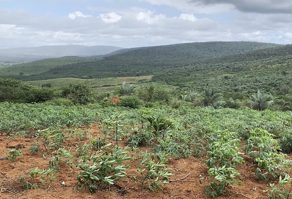
Figure 2. Southern Sector View of the Area
REGIONAL GEOLOGY
The area covered by ANM Process 870.353/2023 is located in a complex geotectonic setting, shaped by the collision between the Jequié and Itabuna-Salvador-Curaçá Blocks during the Paleoproterozoic. This tectonic interaction resulted in intense granulite-facies metamorphism and led to a diversified stratigraphy dominated by high-grade metamorphic rocks.
GEOTECTONIC CONTEXT
The area lies within the central portion of the São Francisco Craton, in the region known as the "Southern Bahia Granulite Belt," where Archean and Paleoproterozoic terrains of the Jequié Block are exposed. This block constitutes one of the main geological compartments of the São Francisco Craton in Bahia and presents distinct petrological and structural characteristics.
The geotectonic evolution of the region is marked by significant collisional events. During the Paleoproterozoic, between 2.1 and 1.9 Ga (billion years ago), the Jequié Block was overridden by the Itabuna-Salvador-Curaçá Block (ISCB) in a major collisional event. This collision triggered intense crustal thickening, deformation, and high-grade regional metamorphism, leading to the formation of extensive granulitic terrains.
The suture zone between these two tectonic blocks represents a geotectonically significant structural feature. Recent studies using structural and geophysical data have contributed to a better delineation between these blocks. (Figure 3 – Tectonic domain map showing the current configuration of the Jequié Block)

Figure 3. Map of Tectonic Domains showing the current configuration of the Jequié Block
STRATIGRAPHY
The Jequié Block is an orthoderived granulitic complex composed of charnockitic, charnoenderbitic, and enderbitic rocks. These rocks are mesocratic to leucocratic, medium- to coarse-grained, with well-defined gneissic banding and occasional migmatization, along with supracrustal rocks that are also granulitized.
Process 870.353/2023 is located in a region geologically classified as the Jequié Complex, comprising the following lithostratigraphic units from base to top (Figure 4):
-
A34jsp – Supracrustal rocks consisting of bands, enclaves, and boudins of basic granulites (basalts and basaltic andesites), quartz-feldspar granulite bands, garnet- and orthopyroxene-bearing or barren cherts/quartzites, graphite schists, banded iron formations, aluminous-magnesian or kinzigitic granulites, and mafic-ultramafic rocks.
-
A34jb – Basic granulites, dark green to black, fine- to medium-grained. Occur as bands or enclaves with centimeter- to meter-scale thickness. Composed of plagioclase, orthopyroxene, clinopyroxene, quartz, opaque minerals, and apatite. Hornblende, biotite, and garnet are occasionally present.
-
A34jch – Serra do Timorante Unit: Granulitic tonalite to granodiorite, gray-brown, medium- to coarse-grained, with feldspar porphyroclasts and localized garnet occurrences. Penetrative foliation and tectonic contact with adjacent units.
-
A34jed – Amargosa-Nova Canaã Unit: Granulitic granite to tonalite interlayered in centimeter-scale bands, gray-green to gray-brown in color, medium- to coarse-grained.
-
A34jpa – Poço d’Anta Unit: Granulitic granodiorite to tonalite, gray-whitish to gray-green, medium- to fine-grained, with foliation parallel to banding and local migmatization features. Locally interlayered with metamafic and metaultramafic rocks.
-
A34jq – Ubaíra Unit, quartzite lithofacies: White-gray to yellow quartzite, sometimes ferruginous, medium- to fine-grained, foliated, and occasionally folded. Locally interlayered with banded iron formation levels.
-
A4jch – Santa Inês–Volta do Rio Unit: Granulitic granite to granodiorite, gray-whitish to light greenish-gray, medium- to coarse-grained, with feldspar porphyroclasts and mafic mineral aggregates, banded, foliated, and occasionally mylonitized. Interlayered with deformed pink syenogranite veins or bands.
-
PP23chb – Brejões Charnockites: Foliated and sometimes banded, coarse- to very coarse-grained, gray-green to dark gray in color. Composed of megacrystals of mesoperthite and quartz immersed in a matrix of mesoperthite, quartz, hornblende, orthopyroxene, clinopyroxene, and subordinately, perthitic microcline, interstitial plagioclase, and biotite. Accessory minerals include opaques, apatite, zircon, myrmekite, sericite, bastite, and rare garnet crystals.
-
PP3lch – Leucocharnockites with garnet and cordierite are massive, medium- to coarse-grained, sometimes fine-grained, and gray-green when fresh, turning whitish upon alteration, highlighting idioblastic garnet crystals. Composed of mesoperthite, quartz, garnet, orthopyroxene, plagioclase and/or antiperthitic plagioclase, biotite, opaques, and cordierite. Clinopyroxene, zircon, and monazite are accessory minerals, while sericite, muscovite, bastite, chlorite (from orthopyroxene alteration), and myrmekite, along with hornblende and biotite, represent retrograde metamorphic phases.
-
NQd – Detrital-lateritic deposits: Unconsolidated to poorly consolidated deposits formed by residual soils with sandy, sandy-clayey, clayey-sandy, and clayey-silty compositions, colored from gray-yellowish to reddish-orange. Contain gravel layers with rounded quartz pebbles. Totally or partially lateritized with ferruginous lateritic crust; levels of lateritic concretions at the contact with the substrate.

Figure 4. Geological map of the Amargosa Sheet (SGB, 2009) adapted with updates from the Jequié Sheet (SGB, 2020) and Manuel Vitorino (SGB, 2020)
STRUCTURAL GEOLOGY
The evolution of the Jequié Block is characterized by the following geological events:
-
3.4 Ga to 3.2 Ga: Formation of an initial continental crust generated by geological processes consistent with a two-stage model, considered responsible for the generation of TTG associations;
-
3.2 Ga to 2.9 Ga: Extensional tectonics with the formation of supracrustal rocks due to the development of an intracratonic basin formed by the separation of the Gavião Block to the west and the Jequié Block to the east;
-
2.4 Ga: Tangential tectonics with frontal ramp structures and strike-slip components, thrusting the Jequié Block over the Contendas-Mirante Greenstone Belt;
-
2.0 Ga: Peak of regional metamorphism in the Jequié Block at granulite facies.
WORKS CARRIED OUT AND RESULTS OBTAINED
As planned, the activities conducted are presented in the following items of this section, in chronological order.
SURVEYS, BIBLIOGRAPHIC AND CARTOGRAPHIC STUDIES
Prior to and during the execution of field activities, bibliographic, cartographic, and geoscientific data were collected and systematized to characterize the regional and local geology of the research area.
Mineral occurrences registered in the Mineral Resources Information System – GeoSGB (CPRM) and the database of the Companhia Baiana de Pesquisa Mineral – CBPM were consulted. High-resolution satellite imagery (Esri Imagery – Alos 30, ESRI-2025 repository) was also used, in addition to geological maps of the Amargosa, Jequié, Jaguaquara, and Maracás sheets, all at a 1:100,000 scale, prepared by the Geological Survey of Brazil (CPRM, 2009 and 2020). In the field, a geological reconnaissance was carried out throughout the area to identify potentially promising targets for sand, for subsequent geological detailing and drilling grid definition.
Additionally, updated topographic maps from open sources (OpenStreetMap) and regional geophysical surveys provided by CBPM and SGB were analyzed, with emphasis on magnetometric and gamma-spectrometric data.
Geographical and spatial data were organized in a georeferenced database, digitized and processed within the QGIS software environment (version 3.40.5 – Bratislava). This integrated database supported the preliminary geological interpretation of the area and provided the technical basis for planning the field campaigns.
GEOLOGICAL RECONNAISSANCE
Fieldwork was mostly carried out by ARCANGEO – Soluções em Geologia e Meio Ambiente, currently responsible for the Mineral Potential Assessment (DPM).
Field activities took place in May 2024 and consisted of a systematic geological reconnaissance campaign aimed at identifying, describing, and evaluating the main lithological units present in the area of mining process no. 870.353/2023. The methodology included traverses with georeferencing of observation points, outcrop descriptions, structural observations, sampling of soil, rock, and pan concentrates, and photointerpretation of satellite images previously processed in a GIS environment. During the field surveys, 66 strategic points distributed across the entire polygon were visited and classified as control, outcrop, and sampling points. (Figure 5)

Figure 5. Map of visited points, adapted from ARCANGEO, 2024
The Archean units of the Jequié Block—granulites, charnockites, etc.—define much of the area. These lithological units occur both in the highland regions and in the flatter portions of the area, often covered by thick layers of clayey soil and residual sediments.

Figure 6. Map of the Anomalous Magnetic Field vs. Tilt Derivative of the Analytic Signal, based on original data from CBPM
As shown in Figure 6, applying the tilt derivative of the analytic signal to CMA-derived data is recommended for mapping structures and mineral exploration targets, enhancing features that are not clearly identified by individual methods. One advantage of this method is that the tilt derivative provides better resolution of body boundaries by equalizing the amplitudes of the CMA. Thus, this technique simultaneously enhances the response of bodies located at different depths. In delineating faults in the area, it is possible to outline the SW/NE fault using negative CMA and confirm it with the tilt derivative, which proves that this regional structure is large-scale and directly influences the definition of drilling targets.
During geological reconnaissance, the predominance of soils grading from yellowish silt to intensely red clay suggested a favorable environment for the hosting of ionic clays (IC). Additionally, the presence of magnetite and heavy minerals in hydraulic flow channels supports the chemical and weathering disaggregation of granulite minerals and their remobilization in low-energy environments.

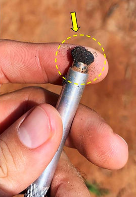
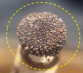
Figure 7. Heavy magnetic minerals in drainage channels on shallow soil
The rocks found near the area, as shown in Figure 8, vary in color from dark green to yellowish, with a predominance of melanocratic, cohesive types, composed of quartz, plagioclase, biotite, pyroxene, magnetite, and opaque minerals, typical of granulite/leucocharnockite. Garnet was occasionally observed, especially in paraderived protoliths.


Figure 8. Macroscopic indicators of iron and manganese oxides
Texturally, these rocks are predominantly isotropic, with weak foliation and limited regional structural orientation trending N50/70. The presence of hypersthene (dark green pyroxene), opaques, and alkaline hornblende are characteristic minerals of the classic charnockite of the Jequié Block. Despite minor mylonitic foliation, it is possible to classify these rocks into host rock, granulite/leucocharnockite, younger dark green charnockite in amphibolite metamorphic facies, and contact zones showing signs of mylonitization, common in the local geotectonic context. These mylonitized zones—transpressional faults—are key structures for the concentration of Rare Earth Elements, as well as other metals.
GEOCHEMICAL SURVEY
The geochemical survey of the area related to ANM process 870.353/2023 employed two main laboratory analysis methods:
X-RAY FLUORESCENCE (XRF72FE)
This method was applied to rock samples (including rock powder) and involves the emission of X-rays that interact with the atoms in the sample, generating characteristic signals for each element. The analysis is fast, non-destructive, and efficient for major elements, though it has limited sensitivity for trace and light elements.
ICP-MS / ICP-OES (ICP95A / IMS95A)
Soil samples, pan concentrates, and sediments were analyzed using ICP, following acid digestion. This technique enables the quantification of trace elements with high precision due to its high sensitivity and multi-element capability, making it ideal for rare earth elements (REE). However, the method is costly, destructive, and dependent on laboratory infrastructure.
Responsible Laboratory: The analyses were conducted by SGS GEOSOL Laboratórios Ltda., accredited with ISO 9001:2015 and ISO 14001:2015 certifications (ABS numbers 32982 and 39911), ensuring international standards of quality and environmental management.
To create raster images of the calculated attributes, the ioGAS 8.20 software was used. The raster of the processed data and its respective legend were exported in SVG format.
MAP OF TOTAL RARE EARTH OXIDES (TREO % and ppm)

Figure 9. Map of Total Rare Earth Oxides in percentage. Map generated using ioGAS 8.20 software

Figure 10. Total Rare Earth Element Oxides in ppm. Generated using ioGAS 8.20 software
The TREO maps in percentage (Figure 11) and in ppm (Figure 12) indicate that the highest concentrations are located in the central and northern regions of the polygon, mainly near samples S3, S4, SD2-C2, SD3-C3, and SD1-C1.
Values exceed 1000 ppm in certain areas, suggesting strong mineral potential. There is a clear correlation with geological structures (faults and anticlines).
THORIUM MAP (Th ppm)
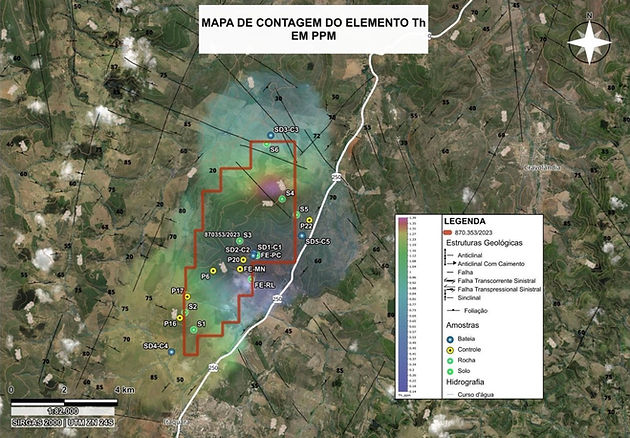
Figure 11. Distribution of Thorium (Th) content in ppm. Generated using ioGAS 8.2 software
The element Th (Thorium) appears with elevated values in the northern part of the area, indicating a possible presence of monazite or other REE-bearing minerals. Samples S3 and S4 are closest to the hotspots.
Th anomalies are associated with major REE deposits within the Jequié Block, currently referred to as the SPVR – Volta do Rio Plutonic Suite, where companies like Equinox Resources, BRE, and GMN are conducting extensive mineral exploration projects.
MAP OF LIGHT MAGNETIC RARE EARTH OXIDES (mREO: Nd2O3 + Pr6O11)

Figure 12. Map showing the distribution of total concentrations of Light Magnetic Rare Earth Oxides (mREO). Generated using ioGAS 8.2 software
The distribution closely follows that of the TREO, with the highest values concentrated in the central portion of the block, emphasizing the presence of light REEs used in permanent magnets. Currently, Neodymium (Nd) and Praseodymium (Pr) are the most sought-after among the 17 Rare Earth Elements, mainly due to their high market value and wide technological applications.
MAP OF HEAVY MAGNETIC RARE EARTH OXIDES (Dy2O3 + Tb4O7)

Figure 13. Map showing the distribution of total concentrations of Heavy Magnetic Rare Earth Oxides (HREO). Generated using ioGAS 8.2 software
The anomalies detected in the northern and northeastern areas, especially near samples S4 and SD3-C3, suggest the presence of heavy REEs with significant technological potential. Dysprosium (Dy) and Terbium (Tb) are combined to assess the economic and technological value of a rare earth deposit, particularly in the permanent magnet industry.
Deposits with meaningful concentrations of these two oxides are considered especially valuable, as Dy and Tb are much rarer and more expensive than Nd and Pr.
MAPS OF HREO AND LREO (Heavy and Light Rare Earth Oxides)

Figure 14. Map of the distribution of total Light Rare Earth Oxide (LREO) contents. Generated using ioGAS 8.2 software
Light Rare Earth Elements (LREO) are widely distributed throughout the central portion of the study area, indicating a distinct concentration environment. Due to their higher mobility, these elements often form supergene deposits in structurally confined settings, as illustrated in the map. They are also more susceptible to weathering processes.

Figure 15. Map of the distribution of total Heavy Rare Earth Oxide (HREO) contents. Generated using ioGAS 8.2 software
Heavy Rare Earth Elements (HREO) are predominantly concentrated in marginal sectors and the northern part of the area, suggesting a possible zoning in the mineralization. Due to their higher atomic weight and specific geochemical affinities, these elements are relatively immobile, tending to remain near their source area.
VOLUME ESTIMATION OF RARE EARTH ELEMENTS (REEs)
The volume estimation presented in this report was carried out based on point geochemical data interpolated using the IDW method, converted into a raster surface, and subsequently analyzed through map algebra in QGIS. This methodology allows for a preliminary estimation of REE volume and content, based on assumptions regarding density and representative thickness. It is emphasized that the values obtained are indicative and must be validated through subsequent systematic sampling and drilling campaigns, in accordance with the guidelines of the National Mining Agency (ANM) for the purpose of mineral resource classification and declaration.
ELEMENTS OF RASTER ALGEBRA AND IMPLICIT OBJECTIVE
To describe the volume estimation (cubagem) process of Rare Earth Elements (REEs), based on point geochemical data and the application of spatial interpolation techniques and raster algebra in the QGIS software.
DATABASE
The database used consists of a CSV file containing sampling points with the following columns:
-
UTM Coordinates (Easting, Northing)
-
Elevation (m)
-
TREO_ppm (concentration of REE oxides in ppm)
PROCESSING IN QGIS
Spatial Interpolation: IDW with 10m pixel, field TREO_ppm.
Clipping with Polygon: using “Clip Raster by Mask Layer”.
Raster Algebra:
Formula applied:
Volume Calculation: Raster Surface Volume tool
Result: 6,905,757,135.61 m³
ESTIMATED REE CONTENT
Tonnage = Volume × ρ = 6,905,757,135.61 × 2.8 = 19,336,119,980 kg = 19.34 Mt
REE content (t) = Tonnage × Average grade = 19,336,119,980 × 0.00065 = 12,568.48 t
This chapter is part of the Final Exploration Report, in compliance with ANM Resolution No. 94/2022, and aims to support the assessment of the mineral potential of the requested area.


Figure 16. Inferred Resources Map. Prepared using QGIS 3.40
FINAL CONCLUSIONS
The Final Exploration Report for ANM process No. 870.353/2023 provides robust technical evidence of significant rare earth element (REE) and iron ore mineralization in the municipalities of Itaquara and Santa Inês (Bahia), within the requested area.
The activities carried out — from bibliographic, geological, and geochemical surveys to laboratory analyses and raster algebra modeling — were conducted in accordance with the parameters established by the National Mining Agency (ANM Resolution No. 94/2022).
The concentrations detected of neodymium (Nd), praseodymium (Pr), dysprosium (Dy), and terbium (Tb) — all of high technological and strategic value — reveal considerable economic potential, especially in the northern and central portions of the study area. Geostatistical modeling indicated an estimated volume of 6.9 billion m³, resulting in approximately 12,568 tonnes of inferred REEs, confirming the project's value for future drilling and feasibility phases.
With low logistical costs, accessible regional infrastructure, favorable climate, and a highly prospective geological context, the area represents a unique opportunity for the advancement of mineral projects focused on energy transition and clean technologies.
BRM therefore concludes that the results obtained not only justify the project's viability but also strengthen the company's strategic position in the national and international critical minerals market.


