
Gold
Cansanção - BA
The area of mining process no. 870.860/2021 occupies 49.66ha and is located in the municipality of Caturama, Bahia, Brazil.

HIGHLIGHTS

Tune in to our exclusive podcast showcasing the Gold & Quartz deposit in Caturama, Bahia.
GENERAL PROCESS DATA
The polygon in question is located in the municipality of Cansanção, Bahia. This ANM process was granted to the titleholder after an auction phase for available areas, which in this case provided the opportunity to acquire the area under the original process No. 871.825/2010.
LOCATION AND LOGISTICS
The polygon of the mining process in focus is situated within the municipal boundaries of Cansanção, State of Bahia (Figure 01).
There are different routes to access the area from the capital, Salvador; however, due to better road conditions and a shorter total distance, the route through the city of Santaluz-BA will be considered here. This route includes the paved highways BR-324 and BA-120, followed by municipal roads from Santaluz and Cansanção leading to the polygon.

Fig 1. Municipal roads between Santaluz and the ANM process area in focus
SURFACE LANDOWNERS
There are only three landowners within the polygon area of the ANM process. The possible spatial distribution, based on updated CAR (Rural Environmental Registry) data, can be observed in Figure 02.
It is worth noting the interest of the landowners in the development of mineral exploration and the implementation of an extraction project, which facilitated the research. Additionally, the properties of Mr. José das Virgens and Mr. “Galego” are considered the most strategically important, as they are geologically the most promising and encompass the main targets.

Fig 2. Map of landowners of ANM Process No. 870.860/2021 according to field data.
MUNICIPAL ASPECTS
The municipality of Cansanção covers a territorial area of 1,351.891 km² (IBGE 2020), has one of the strongest commercial sectors in the sisal macro-region, and serves as one of the main highway junctions in the north-central portion of Bahia. The estimated population in 2022 was 37,439 inhabitants.
Although there are no large-scale mining companies in operation, much of the eastern sector of the municipality shows promising mineral potential for gold and other substances. This is evidenced by the existence of dozens of artisanal mining sites in the region. In the rest of the municipality, land use is dominated by sisal cultivation and general livestock farming.
LOCAL ASPECTS
The area of ANM Process No. 870.860/2021 is located near the “Nova Vida” settlement district, approximately 7.5 km away. The main economic activity there is gold production through dozens of artisanal mining operations scattered in the surrounding area. Sisal cultivation and subsistence livestock farming occur as secondary activities, but are also present.
The district of Nova Vida has treated water supply and electricity for local residents. Rural properties mostly have only electricity, with water supply relying on private sources. Local infrastructure is precarious, with no health clinics, schools, or restaurants, which must be sought in more distant districts.
Specifically within the studied polygon, only livestock farming is carried out by the three landowners. There are gold mining operations nearby, but they are located outside the polygon boundaries.
GENERAL PHYSIOGRAPHIC ASPECTS
The climate in the mining process area under focus, as well as in other regions of the municipality of Cansanção, is similar. It is classified as tropical sub-humid to dry (according to Köppen-Geiger, 1901), with average temperatures above 22 °C and higher rainfall between November and April, coinciding mostly with summer (Figure 03).

Fig. 3. Monthly rainfall and temperatures for the municipality of Araci, Bahia.
Figure 03 shows that, despite wetter summers and colder, drier winters, the region’s average annual rainfall is low, totaling less than 750 mm/year.
The relief of the area results from pediplanation processes over volcanic terrains of the Rio Itapicuru Greenstone Belt, corresponding to a flattened erosive surface marked by low hills and shallow valleys, cut by a drainage system that integrates into the Rio Itapicuru basin (located about 6 km south of the area).
The soils occurring in the proximity of the studied polygon are strongly associated with the local basaltic volcanic unit, where a highly clayey, dark red material predominates, popularly known as “massapê,” technically classified as red latosol (Brazilian Soil Classification System, EMBRAPA, 1999).
The macro-region, as well as the polygon itself, is characterized by dense arboreal caatinga interspersed with pasture areas or sisal plantations. Within the mining process polygon in question, land use is approximately 39% native vegetation and 61% cattle pasture.
GEOTECTONIC EVOLUTION AND REGIONAL GEOLOGY
The regional geology influencing the ANM process area 870.860/2021 is well known and has been characterized by various authors. In summary, it consists of the compartmentalization of the units that make up the crystalline basement and the GBRI (Greenstone Belt of the Rio Itapicuru).
The GBRI is a set of low-grade metamorphosed lithostratigraphic units described below. These metavolcanosedimentary rocks form a zone of preserved ancient rocks with high metallogenetic fertility, in this case geologically overlying the gneiss-migmatitic rocks of the Santaluz Complex, within the Serrinha Block of the São Francisco Craton (SFC).
SÃO FRANCISCO CRATON (SFC)
The SFC developed in a geotectonic context of Archean block accretion during the Paleoproterozoic. This evolution, described primarily by several authors in works such as BARBOSA (1990) and BARBOSA & SABATÉ (2003), highlights the importance and complexity of the geological events associated with this structuring.
The SFC was also considered by ALMEIDA (1971) as a pre-Brasiliano continental basement core, consolidated about 2.08 Ga after the continental convergence of four Archean crustal segments (Figure 05).
BARBOSA & SABATÉ (2003) defined the aforementioned blocks as: Jequié Block, Itabuna-Salvador-Curaçá Belt, Gavião Block, and Serrinha Block — the latter being of greatest interest for understanding the regional geology of the ANM process area in focus.

Fig. 4. Geotectonic map of the collage of blocks that consolidated the formation of the CSF, highlighting the region where the mining process under focus is located. Source: Modified from Barbosa and Sabaté, 2012.
- SERRINHA BLOCK
The Serrinha Block is one of the tectonic compartments comprising the SFC. Various authors, such as Cruz Filho et al. (2005), describe this block as an ellipsoidal mega-structure covering an area of 21,000 km². It is part of the orogenic domain of eastern Bahia, generated during the SFC collisional event that occurred between 2.1 and 2.0 Ga.

Fig. 5. Regional geological map of the Serrinha Block highlighting the area where the mining process in focus is located. Source: Modified from Barbosa and Sabaté, 2012.
- GREENSTONE BELT OF RIO ITAPICURU (GBRI)
The GBRI comprises the main lithostructural units influencing the mineral studies and research carried out in the ANM process area under focus.
This set of metavolcanosedimentary rocks is elongated in a N-S direction, covering an area larger than 7,500 km² across more than 10 municipalities in Bahia. It is interpreted as a remnant of an oceanic arc that collided with an Archean continent approximately 2,130 to 2,105 Ma ago (Oliveira et al., 2010).
Due to the great metallogenetic potential within the GBRI units, numerous research efforts have been undertaken for scientific and exploratory purposes, resulting in large-scale mining of gold in Santaluz and Barrocas and diamonds in Nordestina, for example. This importance is reflected in a rich bibliography on the lithostratigraphic compartmentalization of the GBRI rocks, shown in Figure 6 and summarized as follows:
-
Mafic Metavolcanic Unit (UVM): Occurs throughout the GBRI and consists of massive basaltic flows, with U-Pb age of 2145 Ma (Oliveira et al., 2010), and pillow lavas intercalated with pelitic and chemical sedimentary rocks;
-
Felsic Metavolcanic Unit (UVF): Andesitic to dacitic flows with U-Pb age of 2081 Ma (Oliveira et al., 2010), interlayered with pelites, rhythmites, sandstones, arkosic sandstones, and conglomerates. Pyroclastic rocks such as breccias, agglomerates, ignimbrites, and tuffs are also present;
-
Volcanoclastic Metasedimentary Unit (USV): Composed of turbiditic sequences intercalated with chemical sediments and epiclastic rocks. Around 2110 Ma, intense igneous activity occurred with emplacement of high-K to ultrapotassic plutons at the greenstone–basement transition, generally ellipsoidal and elongated N-S. Notable intrusions include Morro do Afonso syenite, Itareru tonalite, and Fazenda Gavião granodiorite with ages between 2105 and 2110 Ma (Costa et al., 2011).

Fig. 6. Regional geological map of the Granite-Greenstone terrain of the GBRI highlighting the area where the mining process under focus is located. Source: Modified from Barbosa and Sabaté, 2012.
This entire volcanosedimentary sequence was metamorphosed under greenschist facies during basin closure. At this stage, syn-tectonic intrusive bodies emerged, causing higher-grade metamorphism at their margins, with amphibolite facies (Silva, 1992).
Structurally, the GBRI is complexly organized. Differences in rheology among the various rock types, combined with multiple phases of compressive events in the basin, generated a succession of synclines and anticlines bounded by regional shear zones exhibiting sinistral kinematics, oriented N-S in the central-northern portion and E-W in the southern portion (Weber Belt). Two main deformational events affected the sequence (Alves da Silva 1994; Chauvet et al., 1997):
-
D1: Southeast-verging thrusts preserved in the southern GBRI;
-
D2: Resulting from the progression of D1 into a transcurrent tectonics, generating major sinistral N-S shear zones, postdating the emplacement of syn-tectonic granito-gneissic domes (Ruggiero & Oliveira, 2010).
As recognized in other Granite-Greenstone terrains, gold mineralizations in the GBRI are structurally controlled in mesothermal deposit types. Transcurrent shear zones act as primary conduits for hydrothermal fluids, mineralizing altered host rocks and associated quartz veins. This structural control guides exploration activities following mapping and structural identification.
IDENTIFIED MINERAL POTENTIAL
The mineral exploration conducted within the polygon of ANM process 870.860/2021 comprised a total of seven distinct activities carried out during the term of the exploration permit, subdivided according to the central technical development objective of the project:
-
Basic research stages, such as literature review, geoprocessing for the preparation of thematic maps, and local/regional geological reconnaissance, aimed at identifying the mineral potential of the area, enabling a new overall plan and defining the feasibility of further investments.
-
Advancing to more specific exploratory research stages, the central objective shifted to enabling promising targets for a gold mining project. These activities included 1:8,000-scale geological mapping, rock sampling, soil and stream sediment sampling, trench excavation, and data correlation for future exploration planning.
SURVEY OF PRE-EXISTING DATA
This stage aimed at a deeper understanding of the regional and local geology, as well as identifying relevant available information that could optimize the progress of the work.
A literature review was conducted covering various studies in the target region, ranging from scientific articles and academic papers to open publications from private companies that carried out different research and studies in the Rio Itapicuru Greenstone Belt.
Open files from the Companhia Baiana de Pesquisa Mineral (CBPM) and CPRM (Geological Survey of Brazil) provided regional geological maps and important information from airborne geophysical surveys, mining history, geochronology, and structural geology. Examples include data from the Programa Levantamentos Geológicos Básicos do Brasil – Folha SC-24-Y-D Serrinha (CPRM) and the Projeto Mapa Metalogenético do Estado da Bahia (CBPM).
Scientific articles and especially undergraduate theses (TCCs) focusing on gold mineralization at the “Maria Preta – C1” mine, the “Alvo M4” target, and the “Mary Trend”—all approximately 8 km from the study area—clarified the lithostratigraphic subdivision of the central part of the GBRI and the relationship between shear structures, arsenic-bearing sulfide anomalies, and gold.
DEVELOPMENT OF THEMATIC MAPS
Several maps of the study area were created to infer geological and structural information prior to field activities, identify the best access routes, and optimize research work.
Through geoprocessing, maps of traverses, homologous zones, drainage, preliminary geological-structural layout, prospective program, and airborne regional magnetometry were produced. In addition to pre-existing shapefile archives, “ICONOS” and “ALOS” satellite images processed in image-editing software, digital terrain models from NASA and INPE (both with 30 m resolution), 15 m resolution SRTM with four-quadrant illumination, and Google Earth images (2005 to 2020)—which offered excellent quality for the region—were used.
All spatial data were processed and georeferenced (datum WGS 1984, zone 24S) using ArcGIS 10.8.

Fig. 7. Examples of some thematic maps from previous interpretations, which allowed for better planning of subsequent fieldwork stages.
FIELD RECONNAISSANCE
As previously described, the target polygon is located in a geological context extremely favorable for the presence of gold occurrences. Therefore, in addition to reviewing the regional geology and general maps, a regional field reconnaissance was necessary to understand the mineral controls of the dozens of nearby artisanal mines, as well as to verify whether the field data were consistent with observations from the literature.
In total, 19 points were visited during the regional reconnaissance, distributed between outcrops and artisanal mines. Strategic information was also gathered, such as identification of key landowners, land use in the area, vegetation type, and main drainage networks.

Fig. 8. Map of gold occurrences and artisanal mines within the area of influence of the ANM process in focus.

Photo 2. Both photos illustrate some of the artisanal gold mines visited during the regional field reconnaissance. Note the thickness of the clayey soil above the fresh rock, which hinders the identification of mineralized layers without excavation.
DEFINITION OF PROMISING TARGETS
1:8,000 GEOLOGICAL-STRUCTURAL MAPPING
The purpose of the mapping was to identify the main lithotypes present and their surface extent, as well as the primary structural patterns and their influence on the context of gold occurrences.
A total of 117 points were cataloged, divided between “control” and “main” points. During this stage, 46 rock samples (CHIP samples) were also collected, which will be described in the following sections.
In Figure 9, which presents the developed geological map, it is evident that there is no great complexity in rock distribution within the area—something explained by the small size of the polygon. The geological units represented are described below.

Fig. 9. Geological-structural map of the ANM process area in focus. Source: Arcangeo.
LOCAL GEOLOGY
As a result of the mapping, two main geological units were identified in the area:
-
Mafic Volcanic Unit (MVU) – Metabasalts associated with metacherts
Covers approximately 39 ha of the mapped area, located throughout the central and western portions of the polygon, following the general N040° trend. It has structural contact with the neighboring metasedimentary unit to the east and undefined contacts with associated chert cores.
This unit is composed of metabasalts, here observed as light to dark green rocks with aphanitic texture and predominantly mafic composition. Rare millimetric amygdales with plagioclase occur. The rocks are foliated and sometimes fractured, with quartz veinlets aligned to foliation planes. Strong oxidation is frequent along fracture planes (mainly iron and manganese oxides). Sulfides such as pyrite can be seen disseminated in the rock matrix, but are more abundant near shear zones.

Photo 3. The photos illustrate the main type of volcanic rock observed in the unit. In the last image on the right, note the presence of metallic oxidation in fractures—a common feature in these rocks.
Alongside the basalts occur cores of recrystallized siliceous rocks, defined as ferruginous cherts, aligned to the same NE-SW structural trend. Cherts are composed mainly of microcrystalline quartz; in the delimited bands within the area, they show predominantly gray to black coloration with iron oxides. Well-formed quartz crystals in centimeter-scale open spaces are also a distinctive feature.

Photo 4. Both photos show outcrops and macroscopic features of the ferruginous chert in the MVU.
-
Volcanoclastic Metasedimentary Unit – Varied metasediments
Covers approximately 10 ha of the mapped area, occurring from north to south along the eastern side of the polygon with the same general N040° trend.
This unit includes sedimentary rocks rich in siliceous sediments, with minor occurrences of associated andesitic rocks. However, the most prevalent lithologies are various schists, ranging from sericite-quartz schist to muscovite-sericite-quartz schist. Numerous quartz pebbles (white, milky, smoky) occur throughout the unit, interpreted as being linked to the whole unit but more abundant near structural features such as faults and shear zones.
Layers of quartzites, metarenites, metaandesites, phyllites, and cherts are also present. This varied interlayering of lithotypes, combined with the structural development that formed the penetrative foliation in the schists, may have enhanced the geological potential of this unit. The following sections will provide more details on the structural compartmentalization and mineralization controls.
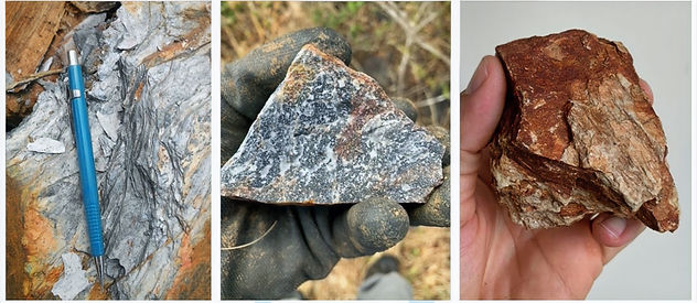
Photo 5. From left to right: Large phyllite cobble, quartzite cobble, and chlorite–quartz–schist cobble, the latter being the predominant rock in the unit in focus.
STRUCTURAL GEOLOGY
Despite the small size of the mapped area, some considerations regarding structural geology are extremely relevant, since in this geological environment, gold mineralization is mainly controlled by structural features.
-
Shear Zones (SZs): They occur following the general trend of the area, accompanying the foliation between N025–045° directions.
During geological mapping, it was not possible to observe the contact between units in outcrop. However, it was possible to infer their presence through the correlation of outcrops and association with topographic structures, with shear zones identified in some of these contacts (see Figure 9). This was determined based on typical features of SZs in the region, such as a large quantity of quartz veins (QVZs) plus quartz cobbles, highly foliated rocks, and sometimes the presence of hydrothermal alteration halos.

Photo 6. From left to right: Sample of altered and deformed basalt in a shear zone; example of smoky quartz with iron oxide; and milky quartz vein with pyrite. All samples were interpreted as being associated with geological structures with high potential for gold mineralization.
-
Foliation: Only a few reliable foliation (Sn) measurements were obtained for the units, mainly from points located within drainage areas, such as P44 and P19, which allowed for observation of rock strike and dip. Trenches also provided such data.
In general, foliation in the area is weakly marked in basalts, whereas in metasediments it is more penetrative and easily visible. Near what was classified as SZs, cobbles are also highly foliated. The identified trend predominantly ranges from N020°–045°, with dips between 65–85° toward the NW.
-
Faults and other structures: Structural lineaments in relief, faults, and fractures were inferred or observed through indirect data such as digital terrain models, satellite imagery, outcrops, and trenches. The individualization of each structure group was not precise; for example, faults and fractures were differentiated only by the degree of rock/cobble fragmentation in the area.
Brittle structures do not appear to have major relevance for the structural control of gold mineralization or for the distribution of the geological units mapped within the area of focus.
ROCK SAMPLING (CHIP SAMPLE)
Rock samples were collected during the geological mapping. They were described and cataloged to feed the project’s database, providing important information on which lithotypes are most promising for the presence of primary gold.
A total of 46 samples were collected, of which only 20 were selected after macroscopic description and analyzed using the Fire Assay analytical method at the “Brastecno” laboratory in Belo Horizonte, MG.
Table 1 below shows the results obtained, and Figure 10 shows their location on the map. The analysis certificates are included in the annexes.

Table 1. General data of rock samples selected and analyzed during the surveys.

Fig 10. Map showing location of samples/results of gold grades in rock. Source: Arcangeo.
The anomaly data identified led to important geological interpretations and assisted in decision-making for exploratory planning, such as soil sampling and trench excavation.
SOIL SAMPLING
Identifying gold anomalies in soil is one way to focus research on more promising targets, especially when combined with other information (e.g., mapping and rock sampling). In this context, 58 samples were collected following a plan based on the results of previous stages.
The methodology used was soil collection to a maximum depth of 20 cm where possible, using a simple manual digger. Good sampling practices were always followed — for example, cleaning tools after each collection to avoid cross-contamination between samples.

Photo 7. Photos show soil sampling with 20 m spacing.

Photo 8. From left to right: process of panning heavy concentrates with the help of a local miner; example of final concentrate from sample SS-4-A; and counting gold specks in an American pan, also for sample SS-4-A.
Each sampling point had its location and altitude recorded. Samples were described, weighed, and panned to concentrate heavy minerals and count gold specks.
Table 2 shows the results of the soil sampling, and Figure 11 shows the location of each point. A correlation between rock anomalies and soil anomalies was observed, further supporting target delimitation for more detailed exploration.

Table 2. General data of soil samples panned for gold speck counting.

Fig 11. Map of soil sampling locations. Source: Arcangeo.
DRAINAGE SAMPLING
Drainage studies in large areas are fundamental and strategic for defining high-potential zones in gold exploration projects. However, despite their relevance to the ANM process in focus, drainage sampling in the area yielded little data volume. This can be explained by:
-
The area’s drainage network is small, all associated with a single sediment catchment basin, which does not allow clear differentiation of distinct gold-bearing potential zones;
-
All assessed drainages showed favorable results for the presence of alluvial gold — meaning the entire polygon is theoretically under the influence of a mineralized zone.
Fig 12. Map showing location of drainage panning concentrate samples. Source: Arcangeo.

Fig. 12. Location map of pan concentrate sampling in drainages of the area. Source: Arcangeo.
The methodology used was simple: using manual tools such as diggers, shovels, and pickaxes, gravel samples were collected at depths ranging from 25–60 cm, covering both deeper gravel and shallow, more recent sediments. These samples were cataloged and weighed, then panned to count gold specks, similarly to the soil sampling process.

Photo 9. From left to right: example of drainage within the evaluated area; illustration of sample CB-11 collection; and result of gold speck count for the same sample, with extremely favorable results.
Reviewing Figure 12 shows that the area has indications of gold throughout its extent, since the drainage network cuts across the predominant NE–SW structural trend, and positive anomalies are found throughout the catchment basin.
TRENCHING
After identifying some soil and rock anomalies and defining the geological structures influencing the area, two trenches were excavated over the metasedimentary geological unit. The trenches aimed to expose the rocks beneath the thick clayey soil covering the area, as well as to allow the collection of structural, geological, and sampling data.
Trenches TR-1 and TR-2 were dug near positive anomaly zones from rock samples AM-REM2 and AM1-STLZ-C. A small backhoe was used, with maximum depths reaching 2.5 m and lengths of about 40 m each. All were logged in profile, and in TR-1, where rocks showed favorable characteristics, a channel sample was collected.

Fig 13. Map showing trench locations in the eastern sector of the area. Source: Arcangeo.

Photo 10. From left to right: logging of material removed from TR-1; and collection of structural data from altered metasediments in TR-2.

Photo 11. Channel sample taken from TR-2, with no relevant gold content identified.
IMPORTANT: The areas of greatest interest to the northwest and southwest of the polygon did not have trenches excavated, despite being planned, due to communication difficulties with the landowner at the time of the work. However, these will be excavated in the next research phases of the project.
CONCLUSIONS
As explained throughout this report, several mineral exploration activities were carried out within the polygon of ANM Process No. 870.860/2021, resulting in the delineation of targets for further work in the search for an economic gold ore deposit. Throughout the course of the work, investments were made in technical activities, reports, laboratory analyses, and various expenses (such as travel, vehicles, local labor, and food), among others, leading to the definition of three high-potential targets for intensified exploration.

Fig. 14. Map of the new targets defined according to the data from the executed surveys. Source: Arcangeo.
Regarding the gold ore, the area shows strong potential to elevate the various occurrences to the status of a deposit and later to that of a mine, a fact supported by several observations, such as:
-
The regional and local geological context of the area is extremely favorable to gold mineralization, whether primary or secondary gold, with several artisanal mining sites just a few meters from the polygon confirming this assertion;
-
The local geology of the polygon presents transitions between mafic metavolcanic and metasedimentary units, in addition to shear zone geological structures with promising mineral assemblages (sulfides, quartz veins/stringers, iron oxides, etc.);
-
The results obtained in the exploration stages proved the existence of highly relevant gold anomalies in soil, drainages, and rocks, which made it possible to define targets that should be further investigated in new exploration phases.
All the content addressed in this report leads to the conclusion that the polygon of ANM Project 870.860/2021 has great mineral potential for gold ore, as well as strategic characteristics suitable for developing an extraction project, making it justifiable to continue exploration in the area.
NEW RESEARCH STAGES
The main objective of continuing mineral exploration in the area is to intensify data collection within the three defined targets. The aim is to determine the economic feasibility of producing the possible existing reserve by obtaining information on the volume, geometry, and spatial distribution of mineralized bodies, average gold grade and contaminants, beneficiation route, and preparation of an Economic Exploitation Plan (PAE).
Phase 1 – All Targets
-
NEW SAMPLING: Additional rock tests will be carried out along with chemical-mineral characterization for the mineralized lithotypes, given that primary gold in the area may or may not be related to hydrothermal alteration “halos,” influencing mineral association and average grade. These activities will provide important details for defining the chemical quality/purity of the gold ore and its beneficiation characteristics.
-
SOIL GEOCHEMISTRY: New soil sampling lines will be carried out, this time focused on the targets and with geochemistry associated with concentrates, thereby increasing the reliability of anomalous data for later trenching planning.
-
GROUND GEOPHYSICS: Geophysical surveys will be important for deeper investigations. The use of IP (Induced Polarization) is expected in cases of anomalous gold-bearing sulfide halos, and electrical resistivity in cases of detecting resistive contrasts between gold-hosting structures and their host rocks.
Phase 2 – Target "A"
-
NEW TRENCHES AND PITS: New trenches and/or pits will be excavated to increase surface data density and better delineate possible mineralized layers. The results, together with geophysical interpretations, will provide the basis for planning the rotary drilling grid.
Phase 3 – Targets "B" & "C"
-
NEW TRENCHES AND PITS: Same approach as above, but applied to targets B and C.
Phase 4 – All Targets
-
DIAMOND CORE DRILLING: Core recovery will be fundamental to confirm grades, volume, and the feasibility of mining the deposit, through measured block modeling. Chemical analyses, petrography, and QA/QC will be part of this stage, which will be programmed in detail according to the results of the previous stages.
-
METALLURGICAL PROCESS ROUTE: The best beneficiation methodologies for the primary ore will be evaluated, aiming to define optimal recovery and purification models for the gold in the potential deposit.

Fig. 15. Exploratory planning map for the technical development of the defined targets. Source: Arcangeo.

